
Ground Penetrating Radar (GPR)
GPR is used to scan through materials to identify defects within or behind.
We have access to multiple antennas and radar source sets, allowing us to scan through most earthy materials such as soil, brick, cement, and stone.
How GPR Works
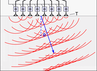
GPR detects subsurface anomalies and objects by measuring the time-of-flight and intensity of reflected radio waves. Our automated GPR system caters to maritime applications, offering automated GPR scans of large areas, reducing manpower and maximizing clarity on subsurface conditions for asphalt, soil, concrete, masonry. Despite its name, GPR is used frequently on surfaces other than the ground.
Key Features
• High-Resolution Imaging: Detailed subsurface views of structural elements up to 2 ft deep.
• Motorized Deployment: GPR antenna can be operated by robotic unmanned systems to accelerate scans.
• Multiple Connection Options: Onboard wifi or wired connection to a controller.
• Cross-Polarization Configurations: Enhances discriminating power for different geometries of subsurface objects.
• Remote Operation: Can be operated from a distance using hardline communication to reach difficult spaces.
• Modular Design: Easily swapped with other aRC instruments like impact testing, ultrasound, and infrared.
Multiple customization options available.
With full-stack fabrication and software capabilities, we can make modifications to radar systems from optimizing them for a target material to ruggedization and form factor changes.
ASTM, ISO, and EN Standard Tools
We use industry-established and leading tools in our robotics platforms. Clients are assured that they are getting accurate and regulatory-acceptable data more efficiently thanks to our robots.
Technical Specifications
• Radar Technology: Stepped-frequency continuous-wave (SFCW) GPR.
• Simultaneous Stepped Frequency: Range of 400 - 6000 MHz.
• Penetration Depth: Variable depending on antenna and material; up to 100 feet.
• Connectivity: WiFi (802.11n) or ethernet or USB-C.
• Autonomy: Motorized antenna deployment.
Applications
• Subsurface Analysis: Detect voids, corrosion, and other abnormalities beneath asphalt, stone, and masonry.
• Subsurface Mapping: Identify subsurface utilities and vulnerabilities for as-built mapping prior to repair work.